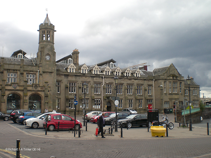
This page allows you to 'virtually visit' Carlisle Citadel Station, the northern limit of the Settle-Carlisle Railway Conservation Area (SCRCA).

Beyond Petteril Bridge Junction, the SCRCA Project covers just two locations: the station and the nearby signal box. Both of these locations lie beyond the SCRCA Project's core area of interest. However, they have been included in the database because they mark the northern terminus of a rail journey through the Settle-Carlisle Railway Conservation Area (SCRCA). To keep things simple, the station has been treated as a single 'structure' (although it is actually a collection of dozens of separate structures). This entire station is a masterpiece of Victorian engineering and it has a fascinating history, both of which more than justify its inclusion in this database. A virtual and / or real-world visit to the station is highly recommended.

1 - Location ID: 308010

Carlisle Power Box / Signal Box (1973 - present)

Photo as per caption. Opens larger version.
Location Type
Signal Box
Location Variant
Signal Box - BR (LMR) type PB+
Current Use(s)
Railway ops
 

Map

The interactive map below shows the approximate location of all the locations currently assigned to this tour. The marker numbers provide a cross-reference to the sequence numbers in the itinerary.

Show / hide tips
  • The maps and aerial imagery will only be displayed if Javascript is installed on your device and enabled for this domain / sub-domain.
  • Note that the marker-positioning is approximate. (It can never be entirely accurate due to slight variations in the positioning of the map / aerial imagery tiles across different map types and scales.)
  • To view brief details for a location in a small overlay window, click / tap on its marker.
  • The layers button (top-right) can be used to switch between two street map layers and an aerial imagery layer. However, please note that interactive mapping makes heavy demands on the internet connection (to download and resize the maps). Page-loading times and data-usage can be kept to a minimum by using the street map layers (#1, esri-world_street_map layer and #2, esri-world_topo_map layer) rather than the aerial imagery layer (#3, esri-world_imagery layer).
  • To view additional information and / or images relating to a location, click / tap on the location's map-marker, then click / tap on the name / brief description in the pop-up window.
  • For additional tips on using the maps and aerial imagery, see "Using the interactive maps".

Practical Considerations

If you are considering a 'real world' visit to Carlisle Citadel Station, you might like to note the following:

  • In addition to a staffed ticket office, this very large station houses a number of commercial retail outlets.
  • The station is located just a few hundred yards from Carlisle city centre. This delightful cathedral city offers a wide variety of local amenities and a visit is highly recommended.
  • Useful information for rail-passengers (e.g. details of station facilities, fares and train times) can be obtained from the following: