This website uses first-party cookies but respects your privacy. When using this website, these Terms and Conditions apply.

Home

aire2eden

78 miles of railway heritage between Hellifield and Carlisle.

Home Settle Carlisle Railway Conservation Area (SCRCA)
  • Virtual Visit
  • Tours
  • Explore
  • Places (Gazetteer)
  • Articles

78 miles of railway heritage between Hellifield and Carlisle

SCRCA structure 240980: Helwith Bridge - Ribblesdale Lime Works Sidings

For the layout of the sidings in 1907, see the map extract in the Image Gallery below, or use the following link to view the full-size version:

  • https://scrca.foscl.org.uk/sites/2/files/drupal/doc/scrca-public-images/Map-Extract-OS-Six-Inch-1910-Foredale-Quarry-and-Ribblesdale-Lime-Works.jpg

For a fascinating collection of aerial photographs showing this huge (but now almost invisible) quarry in operation, see

  • http://www.britainfromabove.org.uk/image/eaw024199
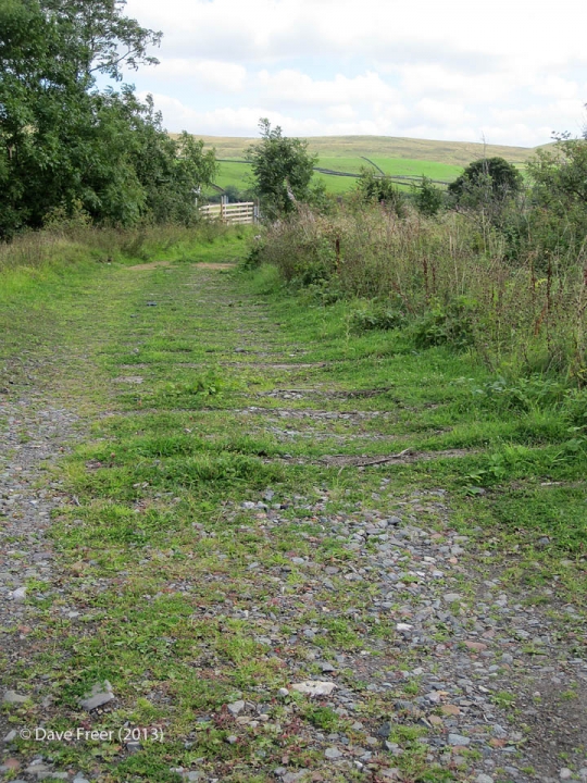
Photo as per title.

Key details from the Location Record

Location Type
Siding
Location Variant
Siding Type - Rail-served industry
Assessment status
Assessed
Current Use(s)
Demolished
Shown on a land plan?
Yes 
  • sac-09-1912
Construction / installation period
0: Construction period unknown
Distance from London St.Pancras
240 miles and 77 chains
Position relative to running lines
Down
Visibility
This location IS visible from nearby publicly accessible land.
Accessibility (ease of access)
Easy
Protection Category
Not Applicable - demolished or relocated
Geographic Location
  View this location on mapping and aerial imagery.

Image Gallery

Tips: To view a larger version of an image, click on its thumbnail (i.e. the small image). To view the acknowledgements and notes associated with an image, click / tap on the image title.

Context views

1957 or early 1958

Helwith Bridge Signal Box & Ribblesdale Lime Works Sidings from Foredale Cottages.

Photo as per caption. Opens larger version.

Elevation views

8 Sep 2013

240980: Ribblesdale Lime Works Sidings: Elevation view from the south east

Photo as per caption. Opens larger version.

Detail views

December 1966

Hudswell Clarke 0-4-0ST loco "Ludo" (wks no 1546) at Ribblesdale Lime Works Sdgs

Photo as per caption. Opens larger version.

Maps

Map revised 1907, published 1910.

Foredale Quarry & Ribblesdale Lime Works: map extract (OS 6", 1910) courtesy of the National Library of Scotland (CC BY-NC-SA 4.0).

Photo as per caption. Opens larger version.

Associated Locations

  • SCRCA site 240951: Helwith Bridge Quarries
  • SCRCA structure 240930: Helwith Bridge Signal Box
  • SCRCA structure 240310: Helwith Bridge Granite Company's Quarry Siding
  • SCRCA structure 240950: Helwith Bridge - New Rail-Link for Arcow and Dry Rigg Quarries

Further Reading (Snippets)

The following 'snippets' contain additional information relating to this location. (To view a snippet, click / tap on its title.)

2017-04-27 - SCRCA Secondary Reference: Aerial photographs on the "Britain from above" website
2015-01-10 - SCRCA Secondary Reference: Review of Anderson & Fox (1986) for 240980
 

Errors and omissions
Reasonable efforts are being made to ensure the accuracy of the information obtained and uploaded as part of the SCRCA Project. However, it is possible that a few errors will have crept-in. If you notice any such errors, we would be grateful if you would bring them to our attention using the SCRCA Project Contact Form. The SCRCA Project Team do NOT guarantee the accuracy of the information contained in this database. If you intend to use and / or act upon any of this information, you are advised to verify its accuracy BEFORE doing so.


SCRCA Project:

  • Introduction and Overview
  • Background and Context
  • Contributors (Acknowledgements)
  • Getting Involved
  • Plea for Information and Images
  • Data Control, Copyright and Usage

Jargon Busting:

  • Glossary of Terms
  • Location Types
  • Location Variants
  • Construction Periods
  • Protection Categories
  • Listed Structures and Scheduled Sites

Further Reading:

  • Building the line
  • Operating the line
  • Historic Structures
  • Conservation & Archaeology
  • General References
  • Site Index

Search:

  • Search this website Search Icon

 
Get in touch:

  • Contact form

 
Social Media:

  •     

The SCRCA Web-Portal was designed and developed by Mark R. Harvey. Moral Rights and Database Rights have been asserted. All text and images are protected by copyright and all rights are reserved.
© Mark R. Harvey
unless otherwise stated. No liability can be accepted for errors or omissions in the information provided on this website, or for any consequences arising therefrom. Back to top Back to top